New phase bypasses more than Lahaina
Popular fishing spot along highway would be all but hidden to westbound drivers
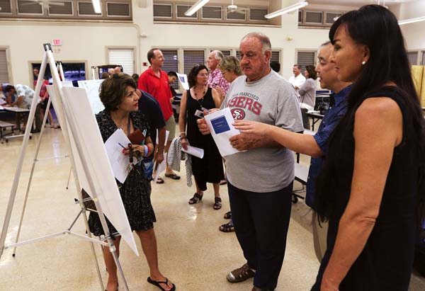
Launiupoko resident Fereshteh Tali (from left) and Lahaina residents Hans Michel and Kai Nishiki (far right) talk with project manager Brian Lock during Wednesday night’s update on the third phase of the Lahaina bypass at Lahaina Intermediate School. The Maui News / CHRIS SUGIDONO photo
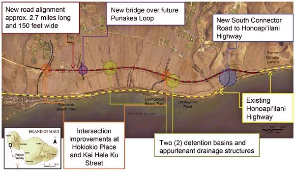
The third phase of the Lahaina bypass project is approximately 2.7 miles long from Hokiokio Place to Honoapiilani Highway near the old Olowalu Landfill. Construction is expected to begin in January and take a year to complete. Wilson Okamoto Corp. illustration

Maintenance engineer Donald Smith of the state Department of Transportation Highways Division Maui District speaks to a crowd of about 40 residents about the third phase of the Lahaina bypass project. The Maui News / CHRIS SUGIDONO photo
Launiupoko resident Fereshteh Tali (from left) and Lahaina residents Hans Michel and Kai Nishiki (far right) talk with project manager Brian Lock during Wednesday night’s update on the third phase of the Lahaina bypass at Lahaina Intermediate School. The Maui News / CHRIS SUGIDONO photo
The third phase of the Lahaina bypass project is approximately 2.7 miles long from Hokiokio Place to Honoapiilani Highway near the old Olowalu Landfill. Construction is expected to begin in January and take a year to complete. Wilson Okamoto Corp. illustration
Maintenance engineer Donald Smith of the state Department of Transportation Highways Division Maui District speaks to a crowd of about 40 residents about the third phase of the Lahaina bypass project. The Maui News / CHRIS SUGIDONO photo
Trending
LAHAINA -- Road access to a popular fishing spot along Honoapiilani Highway is in question as part of the latest phase of the Lahaina bypass.
Planners and designers presented the project's third phase to about 40 people Wednesday night at Lahaina Intermediate School. Plans for construction of the $38.6 million extension, which starts near the old Olowalu landfill and ends at Hokiokio Place, call for beginning work in January and lasting a year.
Residents expressed concerns over the proposed path of the bypass at its southern terminus, where it would veer mauka of Honoapiilani and away from Cut Mountain -- a traditional fishing spot.
Motorists traveling toward Lahaina would have to drive up the new bypass and would not be able to stay on the current coastal highway. To reach Launiupoko Point, drivers would need to turn makai on Kai Hele Ku Street and drive south on the current highway.
Motorists traveling toward Wailuku on the current highway would be able to travel all the way to the bypass road, uphill and mauka of Cut Mountain.
Traffic engineers said that a 1,000-foot section of Honoapiilani Highway makai of Cut Mountain needs to be eliminated for safety and traffic flow reasons. It was unclear whether there would be any motor vehicle access to the coastal area.
"We do not know that yet," said maintenance engineer Donald Smith of the state Department of Transportation's Maui District Highways Division. "At some point in time that will be a future evaluation. I don't want to say anything out of place."
During Wednesday's meeting, officials at first said the current highway would remain in place, but Smith later said that it "may or may not be there." Residents would be able to walk to Cut Mountain, he said, but he didn't know if they would be able to drive and park their vehicles nearby.
"As far as I know, I don't have the right to take your (beach) access, nor would I," he said.
The fishing spot is popular among residents, who can turn off the highway and park their cars and trucks near the water. Tourists also regularly swim at the beach.
Some residents rejected the idea of losing road access to the area and asked that officials be better prepared to answer questions concerning beach access.
"I think it's odd that you can't answer that when you guys designed this road and you're here to give us information about it," said Kai Nishiki of Lahaina. "I think we deserve to have an answer, especially when we're talking about beach access, fishing rights, things like that. That's something the public is very much concerned about."
The project is seeking a shoreline setback variance and a special management area use permit under review by the county Planning Department. Smith said that plans for the area can be addressed during the permitting process.
Smith noted that planners could keep the highway's existing portion and design an intersection to connect the two roads, but they would need to consider other stakeholders such as the state Department of Land and Natural Resources and Maui Police Department. Any time an access point is added, it causes congestion, he said.
"We want to give access and move traffic," he said.
Deputy Planning Director Michele Chouteau McLean said Thursday that the department is aware of the concern over shoreline access and that it is a "relatively new issue." She said that the county owns the land in the area, but "there hasn't been a whole lot of discussion on what to do with it."
The road could be pulled up and land underneath it revegetated, or it could be left alone with a barrier blocking access to the bypass, she said. Talks of making the area a park circulated during Wednesday night's meeting, but she said that the county has not heard anything.
"It doesn't mean it can't be, but it's still too early to decide," she said.
Proposed project improvements include two water retention basins and appurtenant drainage structures along the bypass, a new bridge over the future Punakea Loop and improvements to the intersections at Hokiokio Place and Kai Hele Ku Street. The bypass will be about 2.7 miles long and 150 feet wide.
Other concerns residents had were traffic signals along the bypass that they said would cause congestion in certain areas. Many suggested roundabouts be built instead, even if those cost more.
Smith said that the department's policy for roundabouts is only two lanes and the bypass would eventually have four lanes, so officials did not consider it an option. He added that the circumference for a rural roundabout is much larger than an urban location and there are concerns over speed and other issues.
South and West Maui Sen. Roz Baker said during Wednesday's meeting that she "can't accept that it's off the table," and suggested that the department could change its policies. She said the meeting indicated that the department and planners should not have waited for such a long period from the time the environmental assessment was completed to speaking to the public.
Baker said that residents should know that some issues and concerns can be fixed when the highway goes from two lanes to four lanes in the future. Officials did not have a timetable for when the expansion would happen.
"There's ways that it can be done, but to not understand that there are access issues -- those need to be dealt with seriously and they can be," Baker said.
Baker said that she was not pleased that the state deferred future north phases of the bypass, and she is working with West Maui Rep. Angus McKelvey on restarting them. She said that the north phases are the key to alleviating traffic in Lahaina.
"You got to go north because more people will use it and you'll improve the flow on the interior roads," she said. "We can't let any of this stuff take another 15 years to be completed. It's sort of like if folks that were working on the project and designing the project and lived on the west side they would have a much greater appreciation of what the west side faces."
Smith said that the department is awaiting a start date and going through the bidding process to add dual left-turn lanes off Honoapiilani Highway onto Keawe Street. The intersection has become a nightmare for drivers coming from Kaanapali looking to get on the bypass during morning rush hour.
Smith welcomed the community's input and said that he only arrived to the island recently from Kauai, but he intends to do "everything I can to improve your condition."
"I hope to come to a future meeting where we have more of a blank page, and we can decide what we want to do and try that first roundabout (for the west side)," he said. "I can promise you I'm already looking for a place to put one."
* Chris Sugidono can be reached at csugidono@mauinews.com.