Draft management plan details shared
State DLNR discusses draft Honolua to Honokohau Management Plan

Last December Honolua Bay was busy with surfers. The state is working on a Honolua Bay to Honokohau Management Plan to better manage the area. The Maui News MATTHEW THAYER photo

Cars parallel park along the Honolua Bay dirt access road that overlooks the cliff. Part of the draft Honolua Bay to Honokohau Management Plan proposes to address public safety, overuse, and environmental degradation by limiting parking and controlling access to Honolua. Planning Consultants Hawaii Inc. photo
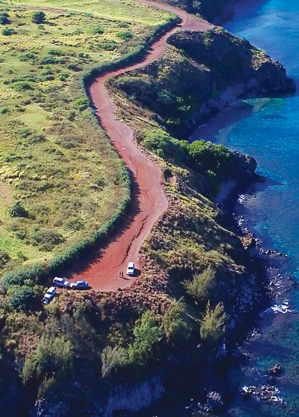
An aerial shot of the Honolua Bay access road during non-peak hours. Planning Consultants Hawaii Inc. photo
Last December Honolua Bay was busy with surfers. The state is working on a Honolua Bay to Honokohau Management Plan to better manage the area. The Maui News MATTHEW THAYER photo
Cars parallel park along the Honolua Bay dirt access road that overlooks the cliff. Part of the draft Honolua Bay to Honokohau Management Plan proposes to address public safety, overuse, and environmental degradation by limiting parking and controlling access to Honolua. Planning Consultants Hawaii Inc. photo
An aerial shot of the Honolua Bay access road during non-peak hours. Planning Consultants Hawaii Inc. photo
Trending
A long term management strategy plan is moving ahead to address issues including overuse, stormwater runoff and water quality along the shoreline and upland areas of state lands between Honolua Bay to Honokohau in West Maui.
Some preliminary recommendations in the draft plan, specifically for Honolua Bay includes hiring staff to manage the area, establishing a daily cap on the number of nonresident visitors and issuing nonresident service fees. It also includes putting in gravel parking stalls to limit and control vehicle access, and having online reservations coupled with an entrance gate where the number of users is counted.
The recommendations were shared Tuesday night during an online informational meeting held by the state Department of Land and Natural Resources which is developing the plan.
The Honolua to Honokohau Management Plan (HHMP), aims to address critical problems facing these areas, such as tourism, stormwater runoff and water quality, climate change impacts, public safety concerns, facility needs, and human overuse, which was the "most significant issue that we heard," said John Summers, vice president of Planning Consultants Hawaii Inc., which is working on the plan with the state.
"The overarching planning goal for the project is really to work with the community to create a community-based management plan," he said. "It really is intended to be a tool that helps the DLNR managers when they are on a day-to-day basis or nonprofit managers that are working with the DLNR helping with management."
The 244-acre property is located makai off of Honoapiilani Highway and includes Honolua Bay, the headland and coastal areas between Lipoa Point and Punalau, Keonehelele'i Beach, and portions of Honokohau Bay.
The property covers nearly four miles of coastline and is one of the last remaining undeveloped shorelines on Maui, according to the DLNR.
After years of collaborative efforts by community groups, Summers said that the state purchased the lands between Honolua Bay and Honokohau Bay from Maui Land & Pineapple Inc. in 2014 after it was threatened with development.
Now the goals is "to preserve the environmental, cultural, and recreational resources," Summers added.
He also pointed to the area's natural beauty and said it is home to marine life, plants, wildlife, cultural resources, preservation and conservation districts, and ocean recreation practices.
The project site is also sacred to Native Hawaiians who "maintain their traditional and customary practices and find the area to be a source of spiritual and physical sustenance," Summers added. "There are tremendous resources within the project area that really make this a special, special place."
Summers also said, "Gentrification is a significant issue in the area, and so there is a real emphasis on trying to ensure that recommendations in the plan are favorable and will ensure that our residents can access the area and feel comfortable in the area." "Environmental stewardship or education is very important (and) the planning area provides an amazing opportunity for site-based education," Summers added.
Other ideas include establishing controlled access trails to discourage trespassing, removing non-indigenous trees and planting natives, installing portable toilets and trash cans within the project site, and working with the state Department of Transportation in removing informal parking access along Honoapiilani Highway by adding signage.
Summers said that the proposed gravel parking lot and controlled roadside parking would have an estimated 15-car and 12-car capacity, respectively, the existing dirt parking area can fit up to 27 cars while the informal parking along the highway can exceed 50 cars during surf swells.
To maintain the character and feel of the area, one of the actions in the proposed plan is to minimize construction and development, he said.
"One thing that came through loud and clear during the planning process was that folks didn't want to see the area change very much," he noted. "There were things that could be helpful, but there was a general consensus that less is more as it relates to physical improvements."
Other components to the 20-year plan involve purchasing the nearby 9.1-acre land in order to better manage that property, which includes restoring Honolua Stream, reviving the surrounding habitats, and maintaining Native Hawaiian farming practices.
To protect and restore natural resources in the Kulaoka'e'a and Lipoa Point project areas, the proposed plans outline very similar ideas as the Honolua project area.
However, Summers said that there was a lot of input from residents requesting a helicopter pad near Honoapiilani Highway above the Lipoa Point access driveway for emergency evacuations.
"So there is a recommendation to do this," he said.
The draft document also proposes to establish seabird restoration areas to protect and restore native seabird colonies along the coastal fringe, which at one time likely hosted diverse populations of breeding seabirds between Pohakupule and Punalau, as well as the portions of Kulaoka'e'a.
The area supports rare and endangered flora and is an important nesting site for native seabirds, Summers said.
To mitigate pollution from the fallow fields at Kulaoka'e'a, pineapple roads will be decommissioned and planted over with native plants or vetiver grass.
For Keonehelele'i Beach, there are proposed plans to improve the parking lot (10-12 stalls), add trash cans and portable toilets, plant native species, and manage the camp ground with priority given to residents.
The entire project is broken into four phases and each phase will take about five years. The 20-year budget for the programs and investments is just over $18 million.
The plan is slated for a review by the Board of Land and Natural Resources in 2023.
The department is seeking public comment and input on the draft HHMP.
To ask questions or make suggestions send email to: jsummers@planningconsultantshawaii.com.
To view more details and recommendations listed in the draft HHMP, see https://dlnr .hawaii.gov/dsp/files/2021/11/111221Public-Review-Draft-HHMP-with-CAP-Reduced .pdf
* Dakota Grossman can be reached at dgrossman@mauinews.com.