State updates sea level rise viewer, a tool to support smarter coastal planning
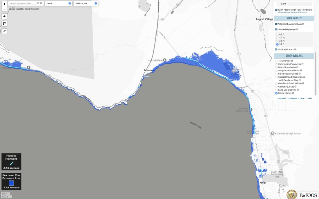
This image of South Maui comes from the updated State of Hawaii Sea Level Rise Viewer. The viewer is meant to help Hawaii residents, planners and officials better understand how their communities could be affected by different sea level rise scenarios. Photo courtesy DLNR
State officials on Friday released an updated interactive map designed to give Hawaii communities a clearer picture of how rising ocean levels could reshape shorelines in the coming decades.
The State of Hawaii Sea Level Rise Viewer maintained by the Hawaii Climate Change Mitigation and Adaptation Commission has been updated to give residents, planners and local officials more insight into the threat facing Hawaii’s coastlines. The view is available at www.pacioos.hawaii.edu/shoreline/slr-hawaii/.
“Sea level rise isn’t a distant forecast — it’s happening now and its impacts are already being felt across Hawaii,” said Leah Laramee, state climate coordinator.
“We need tools like the sea level rise viewer to make informed planning and policy decisions,” she added. “These updates give our communities and leaders clearer, more actionable information so we can plan smarter, protect people and respond to the realities unfolding along our shores.”
The Hawaiian islands are projected to experience up to 4 feet of sea level rise by the end of the century, which is up from earlier predictions of 3.2 feet. Beyond that, the Intergovernmental Panel on Climate Change says sea level rise will continue for thousands of years, even with drastic reductions in greenhouse gas emissions.
First released in 2017, the viewer helps Hawaii residents, planners and beachgoers understand how different sea level rise scenarios may affect their communities.
The most recent update includes expanded data, as well as new guidance for users and social vulnerability indicators.
The “social indicators” layer allows users to view factors that can contribute to vulnerability from sea level rise impacts, such as houses built before 1970.
A new feature is the addition of passive flooding layers between 4 and 8 feet from the National Oceanic and Atmospheric Administration, which provides information about high-tide still-water flooding in higher sea level rise conditions.
The viewer contains descriptions of the NOAA data as well as guidance on when to use different sea level rise scenarios and data sets from state sea level rise reports.
The platform was developed through partnership between the Pacific Islands Ocean Observing System, the Coastal Research Collaborative at the University of Hawaii and the University of Hawaii Sea Grant College Program, along with CCMAC, DLNR, and the Hawaii Office of Planning and Sustainable Development.
To continue these efforts, CCMAC is beginning work on a 10-year update to the 2017 Sea Level Rise Vulnerability and Adaptation Report.
Local News

Photo of the Day: Cheery Dendrobium
Maui Health opens applications for paid summer interns
Maui Health is taking applications for its 2026 Paid Summer Internship Program, offering college students an ...

Kai Pelayo, Stupski Foundation named Volunteer, Benefactor of Year by MEO
Mauliola Pharmacy Founder Cory Lehano to speak on community-driven health systems Feb. 23
Cory Lehano, founder of Mauliola Pharmacy and co-founder of Nohona Health, will be the featured speaker at the ...
Electric and hybrid vehicles nixed for Maui County’s tow and scrap program
Maui County announced Tuesday that its free tow and scrap vehicle recycling program will no longer accept hybrid or ...