
Storm brewing in Pacific could pose risk for Hawaii
Trending
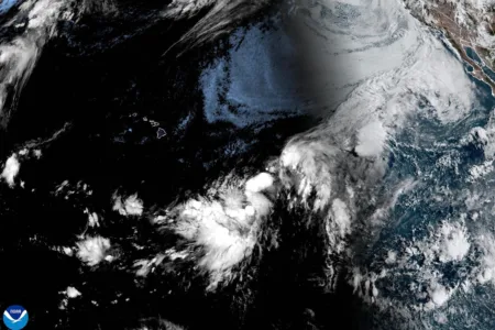
A developing tropical disturbance about 1,000 miles east-southeast of the Hawaiian Islands could bring strong winds, heavy rain, large surf and heightened wildfire danger to the state later this week and into the weekend, according to the National Weather Service in Honolulu.
The National Hurricane Center is monitoring the low-pressure system, which had not yet developed into a tropical cyclone, but was expected to become a tropical depression or storm as it moves generally northwest across the Central Pacific toward the vicinity of the Hawaiian Islands.
Forecasters cautioned that considerable uncertainty remains over the system's eventual track, intensity and proximity to the islands, all of which will determine the severity and location of potential impacts.
Fire weather concerns are expected to increase Friday as winds strengthen ahead of the system and a dry, stable air mass produces low relative humidity. Winds could strengthen further Saturday, with the potential for damaging gusts depending on the storm's track and intensity.
A large easterly swell is also expected to build along east-facing shores, with warning-level surf of 15 feet or higher possible into the weekend.
Flash flooding and rapidly rising streams would be possible if heavy rain persists over the same areas.
Hawaiian Electric said Wednesday it is monitoring the approaching system and preparing for possible impacts as early as Saturday.
The National Weather Service is urging residents and visitors to use the coming days to review hurricane preparedness plans and supplies and not focus on any single forecast model or projected track while the disturbance remains in its early stages of development.