
Taking a long view of hurricanes
Olivia approached Maui from the north, a never-before-seen track
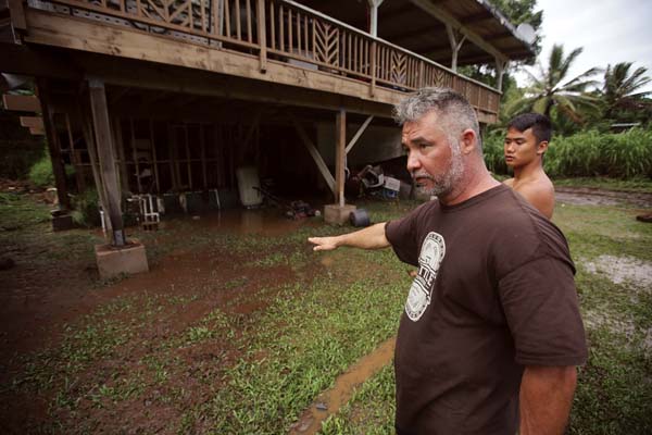
Honokohau Valley resident Mundy Gillcoat describes how high floodwaters from Tropical Storm Olivia raged while standing next to his son Wednesday evening outside their home. After weathering two recent tropical storms, Maui County residents can expect a break to clean up and make repairs with no approaching hurricanes on the horizon — for now. -- The Maui News / CHRIS SUGIDONO photo
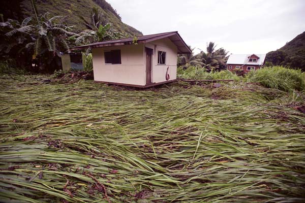
A bedroom building sits atop downed vegetation after being swept up by floodwaters Wednesday afternoon in Honokohau Valley. -- The Maui News / CHRIS SUGIDONO photo
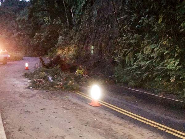
Tropical Storm Olivia made travel on Hana Highway in East Maui treacherous. The rains caused landslides, like this one Wednesday at Mile Marker 14 near Honomanu. -- Hawaii Department of Transportation photo
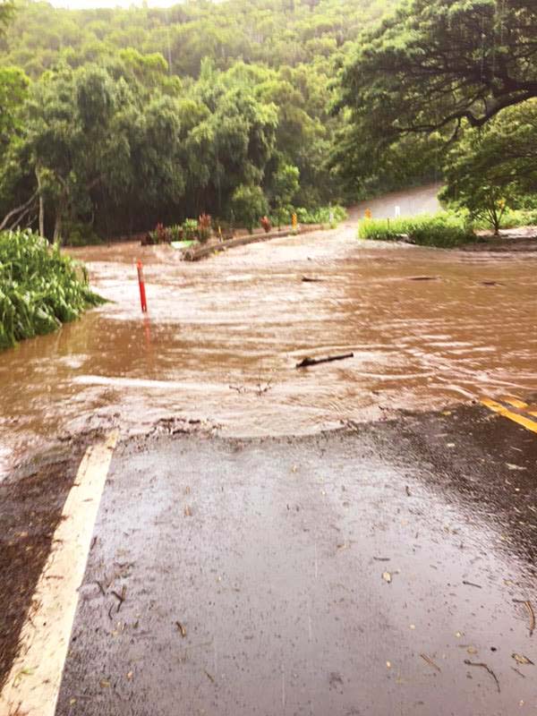
Floodwaters overwhelmed Honolua Bridge in West Maui on Wednesday afternoon. -- Hawaii Department of Transportation photo
Honokohau Valley resident Mundy Gillcoat describes how high floodwaters from Tropical Storm Olivia raged while standing next to his son Wednesday evening outside their home. After weathering two recent tropical storms, Maui County residents can expect a break to clean up and make repairs with no approaching hurricanes on the horizon — for now. -- The Maui News / CHRIS SUGIDONO photo
A bedroom building sits atop downed vegetation after being swept up by floodwaters Wednesday afternoon in Honokohau Valley. -- The Maui News / CHRIS SUGIDONO photo
Tropical Storm Olivia made travel on Hana Highway in East Maui treacherous. The rains caused landslides, like this one Wednesday at Mile Marker 14 near Honomanu. -- Hawaii Department of Transportation photo
Floodwaters overwhelmed Honolua Bridge in West Maui on Wednesday afternoon. -- Hawaii Department of Transportation photo
Trending
After weathering two major storms in three weeks, Hawaii will get a welcome break from hurricanes for the time being.
"It looks pretty quiet in the Eastern Pacific," said Pao-Shin Chu, state climatologist and professor of atmospheric science at the University of Hawaii's School of Ocean and Earth Science Technology. "There's nothing. No hurricanes. . . . So for maybe the next one or two weeks, it's pretty OK."
Maui and Hawaii counties have taken the brunt of the impacts from Hurricane Lane, which curved south of the island chain in late August, and Tropical Storm Olivia, which made landfall on Maui and Lanai on Wednesday. Within the past few weeks, rains have overflowed rivers and swept away portions of homes. Winds have fanned massive brush fires and knocked down trees that caused roadblocks and power outages.
Hurricane season runs from June 1 to Nov. 30, and the flurry of recent activity comes as no surprise to National Weather Service meteorologist Chevy Chevalier.
"Sept. 10 is the peak, and it kind of decreases in frequency after that," Chevalier said. "We've had five (hurricanes): Hector, Lane, Miriam, Norman and Olivia. So I would say we're in the ballpark with the outlook."
In May, the Central Pacific Hurricane Center announced an 80 percent chance of a near- or above-normal season, meaning three to six tropical cyclones -- including tropical depressions, named storms and hurricanes -- in the Central Pacific. While Olivia and Lane may have made the season seem busier than usual, the numbers are still on par with what the center predicted.
"Although it seems slightly abnormal, when you look at it over a long period of time, these are really normal weather patterns," said Erin Hughey, director of disaster services at the Pacific Disaster Center. "I think when we go long periods of time without having tropical activity, it can seem a bit overwhelming."
Hughey said that August and September are when ocean temperatures begin to reach their peak -- and hurricanes "love warm water." While June and July may feel like the hottest months to humans, the ocean, like a large pot of water, needs long, extended periods of warm water and warm air to heat up.
"It's in the August-September time frame when the currents are bringing in warmer water and the air temperature's also heating up," Hughey said.
Tale of two storms
Unlike most storms this season, Lane and Olivia came perilously close to the islands, creating rainfall and flooding that other storms did not. Storms usually come from the east and turn north toward Hawaii, where they often fall apart over cooler waters.
"The boundary between where storms can maintain and where storms can weaken is right around Hawaii, typically like a little bit to the south," said Alison Nugent, assistant professor of atmospheric science at the University of Hawaii's School of Ocean and Earth Science Technology.
Storms are also done in by a factor known as wind shear, which is the difference in wind speed and direction at different levels of the atmosphere. Trade winds are near the surface; winds higher up move in a different direction.
"What happened with Lane was that as it weakened, the upper-level winds that were steering it became less and less important," Nugent said. "As it weakened, it basically got shorter, effectively, and the trade winds became more important. . . . That's why it started moving westward."
Lane, once predicted to pass directly over Maui County, took a near 90-degree turn west, sparing the islands the full force of the storm. Nugent said Lane could've been like Hurricane Iniki, coming from the east and turning north to strike Maui as Iniki did to Kauai in 1992.
However, "because the Big Island is so close, it interferes with the wind patterns around the storm and caused it to weaken," Nugent said. A combination of location and wind shear may have very well spared Maui.
During appearances on TV, Nugent said she got multiple questions from viewers asking whether Maui was "the safest island for storms because we have the Big Island to protect us."
"I found that especially interesting that Olivia came right after, because the track that Olivia took . . . the Big Island couldn't have played a protective role," Nugent said.
Olivia was unusual for a number of reasons -- it was the first tropical storm to make landfall on Maui since modern record-keeping began, and it approached Maui from the north, at a latitude where temperatures aren't usually warm enough to sustain a storm, Nugent said.
Ultimately, it was Hurricane Norman, which weakened to a tropical storm and passed well north of the islands, that impacted Olivia's path.
"As Norman left, the high pressure built in behind it and pushed westward, moving Olivia to the south," Nugent said.
Olivia's path from the north also surprised Chu, who's been a climatologist for 18 years.
"I have a climatic atlas of hurricane tracks," Chu said. "I have never seen anything like that before. . . . Usually it's coming from the east or coming from the south like Iniki or like Iwa (1982)."
Chu said that may be due to climate change. Warmer temperatures not only increase the likelihood of hurricanes but can also impact the routes they take.
"The seawater is relatively cooler compared to the water to the south of us," Chu said. "So hurricanes usually pass to the south of the island chain. This is the normal track. But now maybe because of global warming, the temperature becomes warmer year after year. So maybe that's a reason the hurricane track is moving a little bit northward."
Awaiting El Niño
Perhaps the busiest hurricane season in recent years was 2015, which saw a record-high 16 tropical cyclones and was "a strong El Nino season," Chevalier explained. El Nino and La Nina are the alternating warm and cool phases across the Pacific. El Nino means warmer-than-average sea surface temperatures, while La Nina brings cooler-than-average temperatures, which inhibit hurricane build-up.
"Sea surface temperatures were well above normal. That was a big deal for 2015," Chevalier said. "This year, we're kind of, not full-blown strong El Nino, but it's pretty warm. . . . It's not as strong as 2015 but kind of transitioning still."
The National Weather Service's Climate Prediction Center said Thursday that there was a 50 to 55 percent chance of El Nino developing this fall (September to November), and 65 to 70 percent chance during the winter. Chu said that's unusual, since El Nino conditions usually develop around spring and summertime. Hurricane activity usually tapers off after August and September, but "if El Nino develops, who knows?" Chu said. "Because usually when El Nino occurs, we have a higher frequency of hurricanes here."
Hughey said that scientists like to take the long view, and that "one hurricane season or even five hurricane seasons are not enough to give us the full picture of what's happening within the environment."
"But we do see a trend in warming water and increases in tropical activity," Hughey said. "How that translates over an extended period of time, we're still trying to determine. But we do know that these changes are happening, and we know that changes . . . are going to impact a lot of areas, not just in tropical activity, but in wildfire activity, and in flooding and in snowstorms. So all of these extreme events are going to, we anticipate, continue to increase."
* Colleen Uechi can be reached at cuechi@mauinews.com.