Feedback sought on wetlands map
Maui County is seeking residents’ feedback on the creation of a wetlands map during a public meeting from 6 to 7 p.m. Wednesday at the Maui Ocean Center Sphere in Maalaea.
As part of a new county law to restore and protect wetlands, planning officials are working on a comprehensive map that will identify existing and future wetland areas. The map will eventually launch on the county website and help property owners, land managers and county planners with important land-use decisions, according to a news release.
Facilitated by the county Planning Department, University of Hawai’i Sea Grant College Program and consultant H.T. Harvey and Associates, the meeting next week will gather ideas from the community to help prepare the first draft of the overlay map.
Doors open at 5:30 p.m. Participants can sign up by scanning the QR code or visiting eventbrite.com/e/maui-county-public-scoping-meeting-on-ordinance-5421-wetland-overlay-map-tickets-749593994817?aff=oddtdtcreator.
Those who cannot attend but would like to provide information can contact Long Range Planning Program Administrator Jacky Takakura at longrangedivision@mauicounty.gov or (808) 270-7743.
-
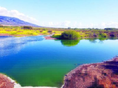
- Wetlands are shown at the Kealia Boardwalk in Maalaea. Photo courtesy Maui County

Local News
Akakū Upstairs to host discussion with filmmakers on July 17
Akakū will host an evening with two Maui filmmakers from 6-7:30 p.m. July 17. Director producers Brian Kohne and ...

Photo of the Day: Crown Flower Buds
Maui United Way invests in nonprofit support with Kahua Grants Initiative
Maui United Way has its first cohort through the Kahua Grants Initiative, a new program designed to support ...
Nominations, candidates sought for open judge’s position
Applications are being accepted for a District Court judge in Maui County. The vacancy was created after District ...
Paddle out, memorials to commemorate anniversary of Maui wildfires
