Wailuku ZIP area has highest number of coronavirus cases
Health Department map shows 6 to 10 for central region
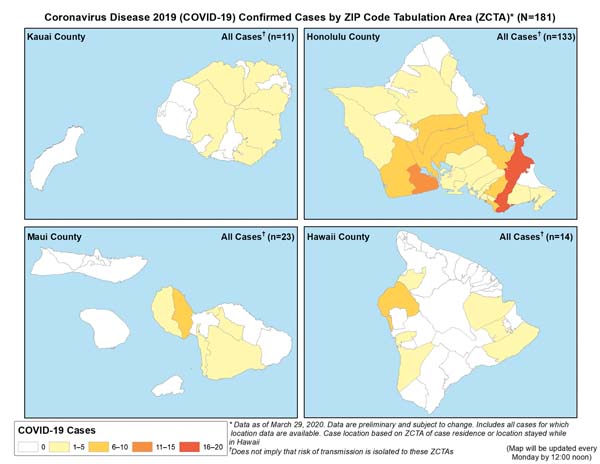
These maps of the islands indicate confirmed cases of coronavirus by ZIP code as of Sunday. The data reflect cases where residency could be confirmed. The Health Department added that the higher concentrations of coronavirus cases in a particular ZIP code do not mean there is a higher risk in the region. Hawaii Department of Health graphic
Wailuku has the highest saturation of the 25 confirmed coronavirus cases in Maui County as of Tuesday, with six to 10 individuals confirmed or presumed positive residing in the area, according to state Health Department officials.
The department released a map on its website showing ZIP codes of individuals who have contracted coronavirus.
However, officials emphasized that the rendering does not mean that there are additional risks in a particular area.
“This is our first attempt to geographically identify those individuals,” state Health Director Dr. Bruce Anderson said during a news conference in Honolulu on Tuesday. “Let me stress so that there’s no confusion, there is no additional risk if you are in those census tracts.
“It’s very likely and, in fact, probable that the person living in those areas was exposed somewhere else.”
Maui County had 25 confirmed cases of coronavirus as of Tuesday noon; of those, six to 10 reside in Wailuku. Areas with one to five cases include Upcountry, South Maui and West Maui, the map shows.
Anderson pointed out that Lanai and Molokai, so far, are without coronavirus cases.
“Maps will show very clearly that there are no cases on Molokai and Lanai at this time, which I think is important and noteworthy,” he said. “But you will see there are cases occurring on all the major islands, other than Molokai and Lanai.”
People residing in areas without coronavirus cases should not feel any safer or let their guard down.
“No one should assume that because they don’t live in a census tract where there’s been a case that they’re not going to be exposed,” Anderson said. “They should act as if they’ve been exposed.”
The health director said that mapping is helpful for planning and strategic purposes, noting where there is evidence of disease and where people are living who have been affected.
The maps do not indicate community spread, he said. “We’re not seeing a lot of clustering,” Anderson said. “In fact, there’s widespread illness reported from census tracts across most of the main Hawaiian Islands.”
State officials said the eight community spread cases are not in the same census tract. Anderson said there is only a handful of cases that are clearly community associated, and there “is no clustering as far as we know in those cases.”
Some hot spots on the maps, like on Oahu where there are more than 10 cases, are associated with earlier reporting when most were travel-related, he said. While he could only speculate, Anderson believed that those higher incidence areas included people who traveled more.
State health officials also reported Tuesday the first positive result from random community COVID-19 tests done on samples from people with flu-like symptoms who tested negative for the flu. A total of 380 samples have been taken statewide, including on Lanai and Molokai, from March 1 to 24.
Anderson said he was not surprised by the first positive test, which “reinforces that there is limited and localized community spread, at least on Oahu.”
State officials did not disclose where the community spread cases are located.
For information, visit health.hawaii.gov/coronavirusdisease2019/what-you-should-know/current-situation-in-hawaii/.
* Kehaulani Cerizo can be reached at kcerizo@mauinews.com.
-
- These maps of the islands indicate confirmed cases of coronavirus by ZIP code as of Sunday. The data reflect cases where residency could be confirmed. The Health Department added that the higher concentrations of coronavirus cases in a particular ZIP code do not mean there is a higher risk in the region. Hawaii Department of Health graphic
Local News
Authorities say they have identified man caught on video throwing rock at monk seal

Maui Indivisible: Hawaii Senate Bill 2471 blazes a trail toward the people-powered government we deserve

USPS considers allowing people to ship handguns through the mail

Hōkūle‘a celebrates 50th anniversary: Double-hulled sailing canoe to visit roots in Taiwan in 2027

Maui High sweeps MIL judo team titles